
Preparing for Fieldwork
Field Supplies
(* = may be borrowed from Plants of Concern or one of our partners)
Plants of Concern Mobile App with assignments loaded, or printed blank paper monitoring form
Clipboard and pencils
Compass
50m tape*
Flags and/or flagging tape*
Permits: required for Illinois Nature Preserve sites and many publicly owned sites. These are usually provided by Plants of Concern. Email Plants of Concern staff if you have questions about permits.
Best Practices in the Field
Avoid Trampling: The more times you visit a site, the more you may impact the subpopulation. Although a small amount of trampling should not harm most subpopulations, follow these simple guidelines to minimize impact:
When returning from a subpopulation, take a different route so as not to create a new trail.
If you visit the site with others, each person should access the subpopulation via a slightly different route rather than walking in a line.
Avoid walking in sensitive areas during rainfall or when the area is wet after recent rains.
Try to remain as stationary as possible when collecting data, moving carefully among the plants when you need to.
Prevent the spread of invasive species: Before leaving or entering a site, check your shoes, clothing, and bags for any seeds that might be ‘hitch-hiking’ and remove them. While on site, take care not to move invasives from place to place. This precaution can help slow the spread of invasive plants. A hand-held boot brush is an indispensable tool that can be stored in your vehicle and used to clean your shoes before and after visiting a site.
Field Safety
Never go into the field alone, and move out of the field when thunderstorms or severe weather threatens. Some items we strongly recommend for safety reasons include: a cell phone, plenty of water, hat, long pants, sturdy shoes or boots, insect repellant, poison ivy wash, and sunscreen.
In Case of an Emergency, use common sense and judgment to ensure your personal safety. Remind those you are with to keep safety in mind, and report potentially unsafe conditions or practices to avoid accidents and injuries.
*FOR SEVERE, IMMEDIATE EMERGENCIES AT ANY SITE CALL 911*
Using the Plants of Concern Mobile App
To start using the Plants of Concern Mobile App for data collection, you must first:
Complete Plants of Concern online training
Create a user account to access monitoring reports
Confirm monitoring assignments for the year
Download or update the Plants of Concern mobile app on the device you will be using in the field, available in the App Store and Google Play
To access your account, log in using your plantsofconcern.org username and password. The home page will show all your assignments for the field season. Contact info@plantsofconcern.org if you have any questions about your assignments.
Use the search bar at the top of the home screen to filter by species and site. The search bar supports both common names and scientific names. Recent updates to the app incorporate newly accepted scientific names, but not their synonyms. For instance, if one of your assignments used to be Tomanthera auriculata (Eared False Foxglove), your assignment will now appear as Agalinis auriculata, which is the accepted scientific name. However, the common name will appear the same, so you can still view and search for Eared False Foxglove, as well as the accepted name.
To the right of the search bar you will find a purple filter icon. Click the icon to filter your assignments by monitoring year, report status, site, and species. The Next Monitoring Year filter is useful if you are assigned a subpop that is not monitored every year, which is uncommon. Select "Current Year" to only view your assigned subpops up for monitoring in the current year. Using the Status filter allows you to view All, Not Started, or In Progress reports, which makes it easy to hide your completed reports from the Assignments page.
The search bar and filter options work in tandem with one another to easily narrow down your assignments.
Back on the Assignments page, select a specific subpopulation to see general information of that subpop. If available, select "Monitoring Tips" to view helpful identification and counting information for that species. This feature is not available for all species yet. Scroll toward the bottom of the page to view the last monitoring report submitted for the subpop.
To begin monitoring, select “Directions” to receive GPS guidance on navigating to the site. Follow the map directions after you arrive at the site. The map will show how far away you are from the subpopulation (in meters) and which cardinal direction you need to go. A large red icon will indicate where the subpop is; the blue dot represents your location. Based on the movement of the blue dot getting closer to the red icon and the meters decreasing, that indicates you are getting closer to the subpopulation.
When you have arrived at the subpopulation, select “Start Monitoring” to open a new monitoring form.
There are 10 data collection sections in the report:
General
GPS
Subpopulation Info
Dominant Natives
Invasives
Impacts
Management
Directions
Monitors
Files
Read the directions to complete each section below.
SECTION 1 GENERAL:
Fill out the date of monitoring.
Respond to each question, indicating if the rare species is present and noting soil conditions.
SECTION 2 GPS:
Click “Edit GPS” to enter Center, North, South, East, and/or West points. Stand at the point of the subpop you are currently recording.
Click “Use Current Location” to record the latitude and longitude to automatically record the point at which you are standing, OR manually enter latitude and longitude values plus an accuracy measurement if you are using an external GPS unit. Here are instructions for using an external GPS unit.
Repeat this process for all the cardinal directions.
Select “Save GPS Point” to save the point and return to the GPS menu to add another point.
Click “Next” when you have finished entering GPS points.
If your subpop did not change locations from the previous monitoring year, you do not need to record new points. For example, if you only want to edit the North point, you can click “edit” and select the N point to edit, while leaving the rest of the points as is.
Select “Next” to continue to record the population area.
Based on your GPS points, the app will automatically calculate the North-South and East-West distances in meters.
If you measured the population using a meter tape and have a more accurate measurement, or you have a small subpop and are only recording a Center point, you can manually enter North-South and East-West distances in the subpop measurements.
Click “Next” to move on to the next section.
SECTION 3 SUBPOPULATION INFORMATION
The app will automatically populate a response to the growth form "What did you count?" question, based on the species you are monitoring and what you should count according to the Plants of Concern database.
If you are counting in a different growth form, click the different growth form option, then click "Ok" to confirm you want to make changes. You should only change the growth form if approved and confirmed by Plants of Concern staff.
Indicate which reproductive phase the plants are in. If you are not sure, select "Don’t Know."
Select your counting method, then click "Next."
The next page is based on the selected counting method:
Direct Count: Enter the total number of reproductive and vegetative individuals. The app will calculate % reproductive automatically.
Transect Estimate: Fill out the length and width of your transect (we recommend 1m width), then click "Add Transact" to enter your transect measurements and count information, indicating how many reproductive and vegetative individuals you counted within the transect. Click “Add Transect” to add another transect count if needed.
Range Estimate: Select which range option correlates to your visual estimate. Estimate the Percent Reproductive value (annual species default to 100% reproductive).
Select “Next” to proceed to the next page.
SECTION 4 DOMINANT NATIVES:
If you monitored the subpopulation before, the app will automatically population the previous dominant native species from the previous report.
To remove a species, click on the "x" next to the species name.
Use the dropdown menu to add species.
You can use the search bar at the top of the dropdown to quickly search for a species.
You can select up to three species each for trees and shrubs & vines and eight species for herbaceous plants. When you select a species to add, you will see a green check mark next to the selected species. Click “Confirm” to add the species.
Repeat these steps for trees, shrubs & vines, and herbaceous species.
Select “Next” to proceed to the next page.
SECTION 5 INVASIVE SPECIES:
If any woody invasive species are encroaching on the subpopulation, indicate the % area of the subpopulation impacted based on the height of the woody invasives (brush <1m and/or brush >1m).
If you see large patches of invasive species within 15 meters of the subpopulation but not directly within the subpop, select “yes” and indicate which species by writing the species names in the text box. Then click "Next."
Click "Add Invasive" to enter individual invasive species. Use the dropdown search box to select an invasive species that is present in the subpopulation, and enter the % area that the invasive species is impacting.
When you have both the invasive species and the % impact selected, select “Add Invasive.”
You may add up to 10 invasive species.
SECTION 6 IMPACTS:
Indicate the % impact for each of the impact categories, then click "Next."
Enter any other impacts by using the dropdown boxes to select the impact, and enter the % impact value. Enter any impact notes, then click "Next."
SECTION 7 MANAGEMENT:
For each section, indicate if management occurred and any evidence you observe that supports your response.
You can select multiple forms of evidence or indicate "Other" to fill in your own explanation.
SECTION 8 DIRECTIONS:
You may copy the directions to the subpop from a previous report, or update or enter new directions if necessary. To copy the previous report's directions, simply click "Copy from Previous Report."
Add any relevant information to the "Notes" section.
SECTION 9 MONITORS:
Use the dropdown box and search bar to add monitors' names to the report. Select "Add Monitor," then search for and save each individual name. You should list whoever is submitting the report as the "Primary Monitor."
Record how long it took you to monitor the subpopulation and any other individuals who assisted in monitoring.
SECTION 10 FILES:
Please upload photos of the plant you monitored (take a close-up and a full-plant view) and unknown associate species. You can select an image from the camera roll or take a new picture.
Plants of Concern staff are happy to help you identify unknown species, and we love seeing and sharing photos of the rare plants you monitor.
When you have finished monitoring, please be sure to submit your data! The completed sections will have "Done!" indicated on the left of each section. Once you complete every section of the report, select "Submit Report."
If you have additional information to enter in your report that is difficult to enter on a mobile device, simply click "Finish on Website" and the report will appear on your Plants of Concern account to be submitted via the website.
Monitoring Protocol
A monitoring report provides a “snapshot in time,” taken in one or possibly two visits when the plants are reproductive. If the population has previously been monitored, try to visit the population within 10 days of the former visit date to ensure consistency. However, if the previous monitoring date was not during the reproductive time, it may be advisable to change the date. Discuss this with Plants of Concern staff.
Lead monitors complete data entry and submission. Other members of the team may take leadership roles in coordinating site visits, following the protocols, etc. All approved monitors for a site and species can view previous reports online, but only the lead monitor can submit data.
There are multiple ways to record and submit data to Plants of Concern:
Plants of Concern Mobile App - a paperless, efficient, and preferred method of using your mobile device to navigate to a subpopulation, record GPS, collect monitoring data and submit your report to the Plants of Concern database all in one step.
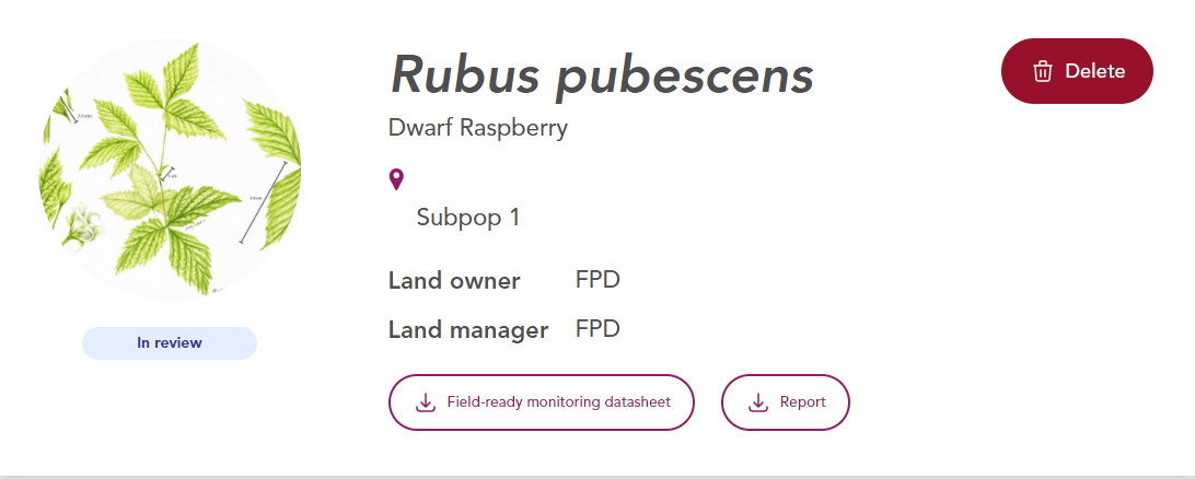
Field-ready monitoring datasheet - this paper datasheet combines previous data with space to record your observations. Print this datasheet from your Plants of Concern Web Account, fill it out in the field, and submit your data, along with a scanned copy of the datasheet through your Web Account.
Blank monitoring datasheet - Record data on a blank monitoring datasheet and submit your data, along with a scanned copy of the datasheet through your Web Account.
Download a blank monitoring datasheet
Section 1: General
Genus, Species, and Variety: This is the scientific name of the species you will monitor. This information will be given to you prior to monitoring.
Site Name: This designates the location of the species you will monitor.
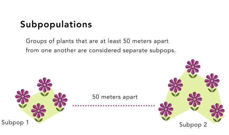
Subpop #: A subpopulation (or “subpop”) is a grouping of plants separated by at least 50 meters (see image below). When monitoring, we define the subpopulation area defined by the outmost individuals of our study species, plus 1 meter. Multiple subpopulations at a single site will each have a unique number. Use the same subpopulation number as established in previous years. If a new subpopulation is found contact staff.
Landowner and Land Manager: This describes the owner and manager of the site you’ll be monitoring at. The land manager may differ from the owner (e.g. CFC manages Baker’s Lake, which is owned by the Barrington Park District). The land manager is typically an agency or organization rather than an individual.
Plants in Subpop Found?: Indicate yes or no. Please complete Sections 2 & 4-7 of the protocol even if plants are not found.
Today’s Soil Condition: Is the soil flooded, saturated, moist, well drained, or dry? The physical condition of the soil can have a large impact on plants. Select the option that reflects the soil condition at the time you are monitoring.
Section 2: GPS Information and Subpopulation Dimensions
Previous GPS Information: Use the written directions and previous GPS points to navigate to the subpopulation.
Recording GPS information: Coordinates are required for new subpopulations or annual species, and should be taken for stable, perennial subpopulations at least every 2-3 years. If plants have not moved or were not found, select ‘GPS is the same as before’, and the previous reading will be carried over.
Please use the decimal degrees coordinate system and WGS 84 datum. If known, record accuracy in meters.
For subpopulations smaller than 13 m x 13 m: take only one reading in the center of the subpopulation. For larger subpopulations: take readings at the plants that are furthest North, South, East, and West. These are indicated by red crosses in the image below. A center reading can be taken for larger subpopulations but is not critical. If a subpopulation is long but less than 13 m wide, take a reading at the beginning, center and end (e.g. record readings for North, Center, and South or West, Center, and East).
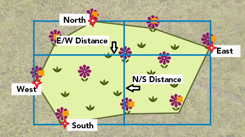
Subpopulation Dimensions: Visualize the subpopulation enclosed in a box that contains all the edges, as in the image above. Measure the subpopulation at its widest points E-W and N-S in meters. Either stand at, or line up with, the furthest plant in each cardinal direction.
If the subpopulation covers an area too large to measure by tape, the mobile app calculates the E-W and N-S distances based on the GPS coordinates.
Section 3: Subpopulation Information
Perennial Species: These are species that can live for more than 1 year. A perennial can exhibit a vegetative (non-flowering) or reproductive (flowering) state. Vegetative individuals can be identified by similar leaf characteristics as flowering individuals. Herbaceous perennials have above ground growth that dies every year. Woody perennials have above ground growth that persists from year to year.
Annual Species: These are species that have a 1-year lifecycle. All individuals are counted as reproductive.
Growth Form: Take note of the growth form designation (e.g., stems, clumps, rosettes) of the species you will be counting, or use the same unit from previous reports. If the growth form given differs from what was used in the past, indicate the difference in the notes section. Contact Plants of Concern staff with questions. See the image below for examples of how plants are counted.
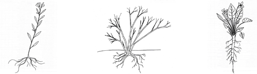 Stems (left), clumps (center), and rosettes (right) are three distinct ways of counting plants.
STEM: a stalk emerging directly from the ground or from the base of the plant, with at least some space between stems (Examples: trees). Even if the stem branches above its point of emergence from the ground, it is still considered a single stem.
CLUMP: a cluster of two or more stems arising from the ground at the same point (Examples: some grasses, sedges and shrubs). Clumped plants may have more than one stem, but the clump should be counted as a single plant. Distinguishing clumps can be challenging in some species. Discuss with staff if you are unsure.
ROSETTE: a circular-shaped vegetative plant form, usually a dense cluster of basal leaves (Examples: dandelions, thistles, violets). A flowering stem bolts from the center of the rosette when the plant matures and flowers.
If the plant you are monitoring does not fit any of these categories, mark “Other” and describe how the plant is growing and what unit was counted.
Reproduction: Monitoring during flowering (or spore-producing) time is the norm. However, your species may have flowering and fruiting individuals at the same time and sometimes there may be both flowers and fruits on the same plant. Indicate the state you find plants in. Indicate if plants are in flower, fruit/spores, flower & fruit, vegetative, or if you don't know. If you are visiting the subpopulation past the period of reproduction, indicate "Don't Know."
Count Method: Indicate the method you use to count plants: Direct Count, Transect Estimate, or Range Estimate. Do a direct count of the numbers of stems, clumps or rosettes if there are 100 or less. Use the transect estimation method if there are too many plants to do a direct count. If you are short on time or flags, you can use the range estimate method and indicate the plant count range.
Total Number: As you count plants, keep track of how many are reproductive and how many are vegetative. The total number of plants is the sum of the reproductive and vegetative plants.
Percent Reproductive: Divide the number of reproductive plants by the total number of plants counted. Annual species are considered 100% reproductive.
Example: You count 34 reproductive (32 flowering + 2 fruiting) & 66 vegetative plants.
34 reproductive + 66 vegetative = 100 plants total
34 reproductive / 100 total = 34% reproductive
If you are estimating the number of plants, use the percentage of reproductive individuals derived from the sample you counted. If you are counting only flowering/fruiting plants because you are unable to identify vegetative individuals, note that 100% of the counted plants are in the reproductive state.
Section 4 : Dominant Natives
Record the dominant native plants; the plants most numerous within and 1-2 meters around the subpopulation. At most, enter the three most abundant trees, three most abundant shrubs, and eight most abundant herbaceous species. On your first visit, the land manager or Plants of Concern staff can help if you are not familiar with all the plants. Lists from previous monitoring reports are available to edit. If you don’t know a plant species, don’t guess; just write down the names of the plants of which you are confident. Submit pictures of unknown species with your data.
Section 5: Invasives
Invasive species can be exotic or native, but are characterized by their negative effect on native plant species. Reference past reports for your subpopulation to see which species could be considered an invasive threat.
Encroachment by species: Record the invasive species present in the subpop and indicate their impact by selecting the percent of the subpopulation covered by each (woody and herbaceous) species. If a species no longer impacts the subpopulation, select ‘None’.
Invasive woody encroachment: Estimate the percent of the subpopulation impacted by all invasive woody plants broken down into the following height categories: Less than (<) 1 meter tall and Greater than (>) 1 meter tall.
Are there invasive species outside the subpopulation area that are not found within? Indicate yes or no, and if yes, list which invasive species. We define “outside” of the subpopulation as the area 15 meters beyond the subpopulation boundary.
Section 6: Impacts
Degree of Impacts: Evaluate all categories, including the percent of the subpopulation affected by each one. If there is no impact, select 'None'. Report immediate threats to the landowner and/or Plants of Concern.
Deer browse on monitored species: Estimate the percent of individuals of the species you are monitoring (% of study plants) that have been browsed. Look for jagged and chewed off stems. You can note other evidence of deer – deer beds, droppings or bark rubbings – under ‘Impact Notes’.
Erosion: Estimate the percent of the subpopulation area impacted by erosion.
Authorized/unauthorized trails: Does either type of trail threaten the plant subpopulation under study? Authorized trails are purposefully constructed by a landowner, and include signed trails, roads, railroads, and paved/gravel paths. Unauthorized trails can include deer paths and ATV trails. Estimate the percent of the subpopulation area impacted. Use the “Impact notes” section to provide detail on authorized/unauthorized trails.
Other: If you notice additional impacts, choose a category in the dropdown menu that best represents the threat and select the percent subpopulation impacted. Use the “Impact notes” section to provide additional detail.
Impact Notes: Include any notes here that clarify impacts you observed.
Section 7: Management
Record management that has occurred within the past year that directly impacts the subpopulation and evidence of that management. Only record management that you can observe or know about from a steward, land manager, or from personal experience. If you’re not sure, indicate ‘Don’t Know’.
Woody invasive removal: Look for freshly-cut stumps within the subpopulation, as well as recently piled brush in the vicinity. If known, indicate which species were removed.
Herbaceous invasive removal: Look for piles of invasives that have been pulled (e.g., sweet clover, garlic mustard), or brown stems that have been treated with herbicide. If known, indicate which species were removed.
Burning: Look for ash on the ground, which would indicate recent burning, or an absence of leaf litter (woodland) or duff (dried matted prairie vegetation).
Section 8: Directions to the Subpopulation and Notes
Directions: Provide detailed directions for first time visits, new subpopulations, or annual plants whose location may change. Be as specific as possible. This information will be used for many years by other monitors and/or researchers. Use as many permanent landmarks as possible in your description (large boulders, roads, buildings, etc.). Start by providing a general location and then get more specific. Refer to the nearest town, route, and parking area. Use local landmarks to create a “trail” for the person to follow, for example: ‘take main trail east for 100 m to large boulder on right and go south for 50m.” If previous directions are effective and no edits are needed you can leave them as-is. If changes are needed, amend or edit previous directions.
Notes: Insert any additional observations you think are relevant, such as reasons for observed changes to subpopulation metrics. If you estimated the number of plants in your subpopulation, detail your methods here.
Section 9: Monitors
Monitor Names, Roles, and Hours: Include names of all monitors and the number of hours each person spent monitoring and submitting data. Indicate which person is the primary monitor and the role each person: participant, volunteer steward, intern, or staff. If a new person helps monitor, they should agree to keeping rare plant locations confidential. Please provide contact information for that person so that Plants of Concern staff can follow up.
Section 10: Files
Please upload photos of the plant you monitored (take a close-up and a full-plant view ), unknown associate species, or a scan of your field datasheet. Pick an image from the camera roll, take a new picture, or upload a file from your computer.
Accessing & Submitting Plants of Concern Data
Go to plantsofconcern.org and log in to My Assignments.
If you have an existing account, you may need to re-set your password the first time you log-in. If you need a new account, contact info@plantsofconcern.org to request a username.
If you forget your password, you can reset it at any time by clicking Forgot Your Password?.
Once logged in, visit the My Account on the right-hand menu to check that we have your correct information on file.
All sites and species assigned to you are listed under "My Assignments" and searchable by using the search bar. Search by typing the species, site or combination of the two in the search bar. Contact Plants of Concern staff if you do not see the correct assignments listed.
After selecting an assignment, you'll see a list of the subpopulations. The "New report" button in the upper right allows you to add a new monitoring report for that subpopulation. Please email info@plantsofconcern.org if you don't see the "New report" button.
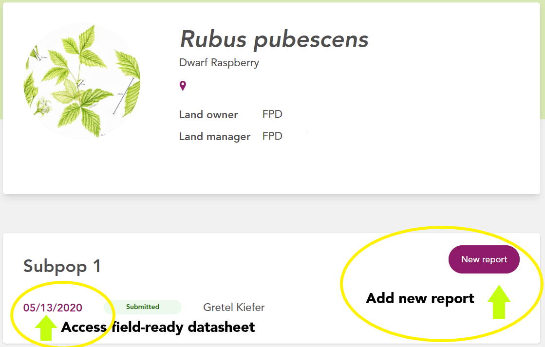
Click on a previous report date to view or print a previous year’s report or print a field-ready datasheet.
Plant Identification Keys
Below are a few guides to help Chicagoland volunteers with identification of associate trees, shrubs, and herbaceous plant species:
Lakeside Daisy Monitoring Protocol
Jenny Finfera, a Fish and Wildlife Biologist with the USFWS in Columbus, OH, created a monitoring protocol for Lakeside Daisy (Tetraneuris herbacea). Ideally, all monitoring of the federally threatened plant will be standardized. If you monitor this wonderful species, please check out the monitoring protocol below, which includes helpful reference photos.